


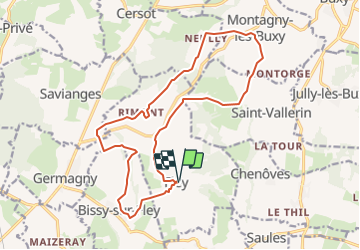
Fley Le Sentier des Orchidées page 113

grasgilbert
User

Length
17.7 km

Max alt
407 m

Uphill gradient
406 m
Km-Effort
23 km

Min alt
264 m

Downhill gradient
403 m
Boucle
Yes
Creation date :
2021-08-10 12:24:29.512
Updated on :
2021-08-10 12:26:52.285
5h14
Difficulty : Medium

FREE GPS app for hiking
 SityTrail
IGN / Geographical institutes
SityTrail Plus
The world is yours!
About
Trail On foot of 17.7 km to be discovered at Bourgogne-Franche-Comté, Saône-et-Loire, Fley. This trail is proposed by grasgilbert.
Positioning
Country:
France
Region :
Bourgogne-Franche-Comté
Department/Province :
Saône-et-Loire
Municipality :
Fley
Location:
Unknown
Start:(Dec)
Start:(UTM)
625582 ; 5169789 (31T) N.
Comments