


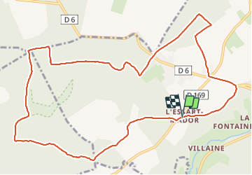
Forêt de Lyons - L'Essart Mador - La Pierre Fortelle et Taisnières

marcel.F
User

Length
12.6 km

Max alt
181 m

Uphill gradient
166 m
Km-Effort
14.8 km

Min alt
68 m

Downhill gradient
164 m
Boucle
Yes
Creation date :
2021-08-10 12:17:56.19
Updated on :
2021-08-10 17:21:17.338
2h09
Difficulty : Difficult

FREE GPS app for hiking
 SityTrail
IGN / Geographical institutes
SityTrail Plus
The world is yours!
About
Trail Walking of 12.6 km to be discovered at Normandy, Eure, Lyons-la-Forêt. This trail is proposed by marcel.F.
Description
départ Chapelle Saint Jean à l'Essart Mador (Lyons la Forêt)
Positioning
Country:
France
Region :
Normandy
Department/Province :
Eure
Municipality :
Lyons-la-Forêt
Location:
Unknown
Start:(Dec)
Start:(UTM)
387138 ; 5472602 (31U) N.
Comments