


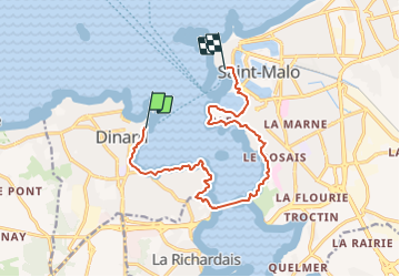
Saint Malo-10 La Rance maritime

nicolas54230
User

Length
13 km

Max alt
39 m

Uphill gradient
204 m
Km-Effort
15.7 km

Min alt
0 m

Downhill gradient
219 m
Boucle
No
Creation date :
2021-08-10 18:28:30.659
Updated on :
2021-08-10 18:29:09.284
3h34
Difficulty : Easy

FREE GPS app for hiking
 SityTrail
IGN / Geographical institutes
SityTrail Plus
The world is yours!
About
Trail On foot of 13 km to be discovered at Brittany, Ille-et-Vilaine, Dinard. This trail is proposed by nicolas54230.
Positioning
Country:
France
Region :
Brittany
Department/Province :
Ille-et-Vilaine
Municipality :
Dinard
Location:
Unknown
Start:(Dec)
Start:(UTM)
569979 ; 5387189 (30U) N.
Comments