


Semnoz DH

kipoura
User
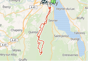

Length
32 km

Max alt
1693 m

Uphill gradient
1352 m
Km-Effort
50 km

Min alt
517 m

Downhill gradient
1356 m
Boucle
No
Creation date :
2021-08-11 13:59:58.081
Updated on :
2021-08-11 14:04:55.303
3h29
Difficulty : Very difficult

FREE GPS app for hiking
 SityTrail
IGN / Geographical institutes
SityTrail Plus
The world is yours!
About
Trail Mountain bike of 32 km to be discovered at Auvergne-Rhône-Alpes, Upper Savoy, Annecy. This trail is proposed by kipoura.
Positioning
Country:
France
Region :
Auvergne-Rhône-Alpes
Department/Province :
Upper Savoy
Municipality :
Annecy
Location:
Annecy
Start:(Dec)
Start:(UTM)
277508 ; 5085936 (32T) N.
Comments