


2021 08 BAGNOLS T3

michel1025
User
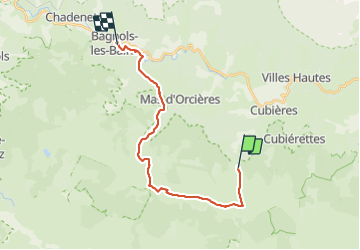

Length
20 km

Max alt
1699 m

Uphill gradient
385 m
Km-Effort
27 km

Min alt
910 m

Downhill gradient
949 m
Boucle
No
Creation date :
2021-08-11 07:40:48.0
Updated on :
2021-08-11 15:00:52.73
6h19
Difficulty : Very difficult

FREE GPS app for hiking
 SityTrail
IGN / Geographical institutes
SityTrail Plus
The world is yours!
About
Trail Walking of 20 km to be discovered at Occitania, Lozère, Cubières. This trail is proposed by michel1025.
Positioning
Country:
France
Region :
Occitania
Department/Province :
Lozère
Municipality :
Cubières
Location:
Unknown
Start:(Dec)
Start:(UTM)
559533 ; 4921618 (31T) N.
Comments