


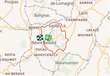
Montgaillard pr7 circuit des potiers

Glurps
User

Length
10 km

Max alt
256 m

Uphill gradient
243 m
Km-Effort
13.3 km

Min alt
163 m

Downhill gradient
248 m
Boucle
Yes
Creation date :
2021-08-11 14:00:32.0
Updated on :
2021-08-11 16:30:15.762
2h28
Difficulty : Easy

FREE GPS app for hiking
 SityTrail
IGN / Geographical institutes
SityTrail Plus
The world is yours!
About
Trail Walking of 10 km to be discovered at Occitania, Tarn-et-Garonne, Montgaillard. This trail is proposed by Glurps.
Positioning
Country:
France
Region :
Occitania
Department/Province :
Tarn-et-Garonne
Municipality :
Montgaillard
Location:
Unknown
Start:(Dec)
Start:(UTM)
329584 ; 4866540 (31T) N.
Comments