


#1- CHEMIN D'AUDRIEU

yannick-p
User
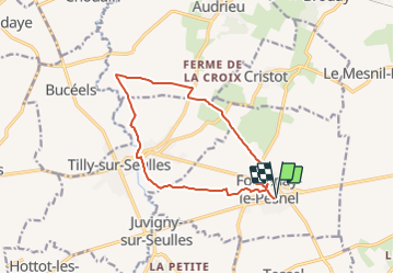

Length
12.3 km

Max alt
104 m

Uphill gradient
126 m
Km-Effort
14 km

Min alt
50 m

Downhill gradient
126 m
Boucle
Yes
Creation date :
2021-08-11 21:27:31.213
Updated on :
2021-08-11 21:32:23.747
4h00
Difficulty : Easy

FREE GPS app for hiking
 SityTrail
IGN / Geographical institutes
SityTrail Plus
The world is yours!
About
Trail Geocaching of 12.3 km to be discovered at Normandy, Calvados, Fontenay-le-Pesnel. This trail is proposed by yannick-p.
Positioning
Country:
France
Region :
Normandy
Department/Province :
Calvados
Municipality :
Fontenay-le-Pesnel
Location:
Unknown
Start:(Dec)
Start:(UTM)
676670 ; 5449102 (30U) N.
Comments