


étang de Fréteval

raab
User
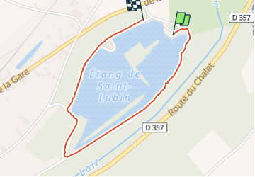

Length
1.8 km

Max alt
92 m

Uphill gradient
10 m
Km-Effort
1.9 km

Min alt
85 m

Downhill gradient
8 m
Boucle
Yes
Creation date :
2021-08-12 08:03:30.589
Updated on :
2021-08-12 08:37:27.759
33m
Difficulty : Easy

FREE GPS app for hiking
 SityTrail
IGN / Geographical institutes
SityTrail Plus
The world is yours!
About
Trail Walking of 1.8 km to be discovered at Centre-Loire Valley, Loir-et-Cher, Fréteval. This trail is proposed by raab.
Positioning
Country:
France
Region :
Centre-Loire Valley
Department/Province :
Loir-et-Cher
Municipality :
Fréteval
Location:
Unknown
Start:(Dec)
Start:(UTM)
367351 ; 5306170 (31T) N.
Comments