38 bournillon porte du diable charmatte

randodyssée
User GUIDE

Length
16.5 km

Max alt
1259 m

Uphill gradient
1336 m
Km-Effort
34 km

Min alt
315 m

Downhill gradient
1314 m
Boucle
Yes
Creation date :
2021-08-12 06:57:13.379
Updated on :
2021-08-13 15:29:22.447
8h07
Difficulty : Difficult

FREE GPS app for hiking
 SityTrail
IGN / Geographical institutes
SityTrail Plus
The world is yours!
About
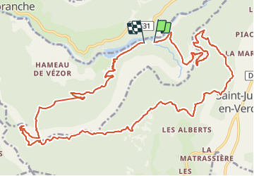
Trail Walking of 16.5 km to be discovered at Auvergne-Rhône-Alpes, Isère, Châtelus. This trail is proposed by randodyssée.
Description
Jack sylv
Photos


Positioning
Country:
France
Region :
Auvergne-Rhône-Alpes
Department/Province :
Isère
Municipality :
Châtelus
Location:
Unknown
Start:(Dec)
Start:(UTM)
691095 ; 4992540 (31T) N.
Comments