


randonnee-st-michel-de-chabrillanoux-les-belvederes nMVVYmMNtY4fACzh8d3-Xw

Linerou
User

Length
11.8 km

Max alt
547 m

Uphill gradient
575 m
Km-Effort
19.4 km

Min alt
190 m

Downhill gradient
573 m
Boucle
Yes
Creation date :
2021-08-13 17:40:31.76
Updated on :
2021-08-13 17:41:55.703
4h24
Difficulty : Difficult

FREE GPS app for hiking
 SityTrail
IGN / Geographical institutes
SityTrail Plus
The world is yours!
About
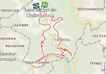
Trail Walking of 11.8 km to be discovered at Auvergne-Rhône-Alpes, Ardèche, Saint-Michel-de-Chabrillanoux. This trail is proposed by Linerou.
Positioning
Country:
France
Region :
Auvergne-Rhône-Alpes
Department/Province :
Ardèche
Municipality :
Saint-Michel-de-Chabrillanoux
Location:
Unknown
Start:(Dec)
Start:(UTM)
626656 ; 4966439 (31T) N.
Comments