


francette j14 le dernier Montgiroux Mayenne

werth
User
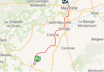

Length
15.2 km

Max alt
112 m

Uphill gradient
204 m
Km-Effort
17.8 km

Min alt
72 m

Downhill gradient
171 m
Boucle
No
Creation date :
2021-08-14 07:14:54.44
Updated on :
2021-08-14 08:46:08.061
1h29
Difficulty : Easy

FREE GPS app for hiking
 SityTrail
IGN / Geographical institutes
SityTrail Plus
The world is yours!
About
Trail Bicycle tourism of 15.2 km to be discovered at Pays de la Loire, Mayenne, Martigné-sur-Mayenne. This trail is proposed by werth.
Positioning
Country:
France
Region :
Pays de la Loire
Department/Province :
Mayenne
Municipality :
Martigné-sur-Mayenne
Location:
Unknown
Start:(Dec)
Start:(UTM)
670661 ; 5342523 (30U) N.
Comments