


Montpezat lalbenque pilou

Glurps
User

Length
30 km

Max alt
280 m

Uphill gradient
403 m
Km-Effort
35 km

Min alt
176 m

Downhill gradient
445 m
Boucle
No
Creation date :
2021-08-14 08:49:04.0
Updated on :
2021-08-14 11:16:58.795
2h27
Difficulty : Difficult

FREE GPS app for hiking
 SityTrail
IGN / Geographical institutes
SityTrail Plus
The world is yours!
About
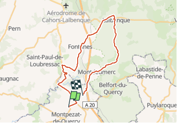
Trail Road bike of 30 km to be discovered at Occitania, Tarn-et-Garonne, Montpezat-de-Quercy. This trail is proposed by Glurps.
Photos

Positioning
Country:
France
Region :
Occitania
Department/Province :
Tarn-et-Garonne
Municipality :
Montpezat-de-Quercy
Location:
Unknown
Start:(Dec)
Start:(UTM)
378674 ; 4900784 (31T) N.
Comments