


st aubin de cretot

dedejojo
User
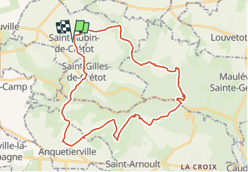

Length
20 km

Max alt
148 m

Uphill gradient
476 m
Km-Effort
26 km

Min alt
26 m

Downhill gradient
476 m
Boucle
Yes
Creation date :
2021-08-13 08:05:20.92
Updated on :
2021-08-15 07:55:45.693
6h17
Difficulty : Very easy

FREE GPS app for hiking
 SityTrail
IGN / Geographical institutes
SityTrail Plus
The world is yours!
About
Trail Walking of 20 km to be discovered at Normandy, Seine-Maritime, Saint-Aubin-de-Crétot. This trail is proposed by dedejojo.
Positioning
Country:
France
Region :
Normandy
Department/Province :
Seine-Maritime
Municipality :
Saint-Aubin-de-Crétot
Location:
Unknown
Start:(Dec)
Start:(UTM)
329141 ; 5493284 (31U) N.
Comments