


De St Quentin à Moy de l'Aisne

BrassensJC
User
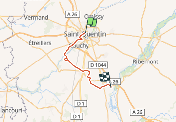

Length
24 km

Max alt
115 m

Uphill gradient
186 m
Km-Effort
27 km

Min alt
58 m

Downhill gradient
234 m
Boucle
No
Creation date :
2021-08-16 11:37:38.67
Updated on :
2021-08-16 12:08:15.181
6h04
Difficulty : Very difficult

FREE GPS app for hiking
 SityTrail
IGN / Geographical institutes
SityTrail Plus
The world is yours!
About
Trail Walking of 24 km to be discovered at Hauts-de-France, Aisne, Saint-Quentin. This trail is proposed by BrassensJC.
Description
nuit à la ferme d'Alice rue Achille Langlet
Positioning
Country:
France
Region :
Hauts-de-France
Department/Province :
Aisne
Municipality :
Saint-Quentin
Location:
Unknown
Start:(Dec)
Start:(UTM)
520772 ; 5521708 (31U) N.
Comments