


La Rosière Rando bleue bergerie

domifon
User
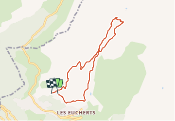

Length
7.8 km

Max alt
2110 m

Uphill gradient
353 m
Km-Effort
12.5 km

Min alt
1868 m

Downhill gradient
362 m
Boucle
Yes
Creation date :
2021-08-17 07:00:16.0
Updated on :
2021-08-17 09:57:47.883
2h55
Difficulty : Medium

FREE GPS app for hiking
 SityTrail
IGN / Geographical institutes
SityTrail Plus
The world is yours!
About
Trail Walking of 7.8 km to be discovered at Auvergne-Rhône-Alpes, Savoy, Montvalezan. This trail is proposed by domifon.
Positioning
Country:
France
Region :
Auvergne-Rhône-Alpes
Department/Province :
Savoy
Municipality :
Montvalezan
Location:
Unknown
Start:(Dec)
Start:(UTM)
332778 ; 5055187 (32T) N.
Comments