


Chambon sur Cisse

nolsim
User
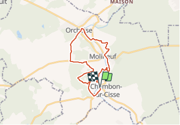

Length
12.4 km

Max alt
132 m

Uphill gradient
216 m
Km-Effort
15.3 km

Min alt
73 m

Downhill gradient
213 m
Boucle
Yes
Creation date :
2021-08-19 08:30:35.142
Updated on :
2021-08-19 12:59:46.838
3h21
Difficulty : Easy

FREE GPS app for hiking
 SityTrail
IGN / Geographical institutes
SityTrail Plus
The world is yours!
About
Trail Walking of 12.4 km to be discovered at Centre-Loire Valley, Loir-et-Cher, Valencisse. This trail is proposed by nolsim.
Photos


Positioning
Country:
France
Region :
Centre-Loire Valley
Department/Province :
Loir-et-Cher
Municipality :
Valencisse
Location:
Unknown
Start:(Dec)
Start:(UTM)
365574 ; 5269296 (31T) N.
Comments