


Balade pas top à couvron

jojo02
User

Length
13.6 km

Max alt
121 m

Uphill gradient
134 m
Km-Effort
15.4 km

Min alt
59 m

Downhill gradient
134 m
Boucle
Yes
Creation date :
2021-08-19 15:53:36.0
Updated on :
2021-08-19 17:13:26.572
1h19
Difficulty : Easy

FREE GPS app for hiking
 SityTrail
IGN / Geographical institutes
SityTrail Plus
The world is yours!
About
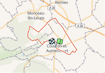
Trail Mountain bike of 13.6 km to be discovered at Hauts-de-France, Aisne, Couvron-et-Aumencourt. This trail is proposed by jojo02.
Positioning
Country:
France
Region :
Hauts-de-France
Department/Province :
Aisne
Municipality :
Couvron-et-Aumencourt
Location:
Unknown
Start:(Dec)
Start:(UTM)
537257 ; 5499159 (31U) N.
Comments