


Plan de la Lai-Col du Bresson A/R

nicolas54230
User
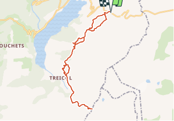

Length
21 km

Max alt
2471 m

Uphill gradient
1347 m
Km-Effort
38 km

Min alt
1787 m

Downhill gradient
1347 m
Boucle
Yes
Creation date :
2021-08-19 18:16:41.032
Updated on :
2021-08-19 18:19:09.253
8h44
Difficulty : Very difficult

FREE GPS app for hiking
 SityTrail
IGN / Geographical institutes
SityTrail Plus
The world is yours!
About
Trail Walking of 21 km to be discovered at Auvergne-Rhône-Alpes, Savoy, Beaufort. This trail is proposed by nicolas54230.
Positioning
Country:
France
Region :
Auvergne-Rhône-Alpes
Department/Province :
Savoy
Municipality :
Beaufort
Location:
Unknown
Start:(Dec)
Start:(UTM)
318594 ; 5062578 (32T) N.
Comments