


le reculet-crêt de la neige

Titinechris
User
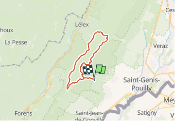

Length
23 km

Max alt
1710 m

Uphill gradient
1322 m
Km-Effort
41 km

Min alt
842 m

Downhill gradient
1341 m
Boucle
Yes
Creation date :
2021-08-19 19:47:03.829
Updated on :
2021-08-19 19:48:04.408
9h16
Difficulty : Very difficult

FREE GPS app for hiking
 SityTrail
IGN / Geographical institutes
SityTrail Plus
The world is yours!
About
Trail Walking of 23 km to be discovered at Auvergne-Rhône-Alpes, Ain, Thoiry. This trail is proposed by Titinechris.
Positioning
Country:
France
Region :
Auvergne-Rhône-Alpes
Department/Province :
Ain
Municipality :
Thoiry
Location:
Unknown
Start:(Dec)
Start:(UTM)
728028 ; 5125822 (31T) N.
Comments