


chevadieres

pjoly
User
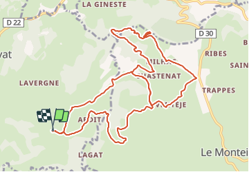

Length
13.5 km

Max alt
848 m

Uphill gradient
465 m
Km-Effort
19.7 km

Min alt
592 m

Downhill gradient
467 m
Boucle
Yes
Creation date :
2021-08-20 08:21:45.845
Updated on :
2021-08-20 09:21:20.356
59m
Difficulty : Easy

FREE GPS app for hiking
 SityTrail
IGN / Geographical institutes
SityTrail Plus
The world is yours!
About
Trail Mountain bike of 13.5 km to be discovered at Auvergne-Rhône-Alpes, Cantal, Sauvat. This trail is proposed by pjoly.
Positioning
Country:
France
Region :
Auvergne-Rhône-Alpes
Department/Province :
Cantal
Municipality :
Sauvat
Location:
Unknown
Start:(Dec)
Start:(UTM)
457412 ; 5016671 (31T) N.
Comments