


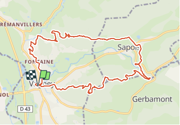
vagney-13km

ZAMBAUX
User

Length
12.4 km

Max alt
613 m

Uphill gradient
424 m
Km-Effort
18 km

Min alt
401 m

Downhill gradient
423 m
Boucle
Yes
Creation date :
2021-08-20 07:09:27.766
Updated on :
2021-08-20 13:52:42.486
6h40
Difficulty : Difficult

FREE GPS app for hiking
 SityTrail
IGN / Geographical institutes
SityTrail Plus
The world is yours!
About
Trail Walking of 12.4 km to be discovered at Grand Est, Vosges, Vagney. This trail is proposed by ZAMBAUX.
Description
rando agréable
Positioning
Country:
France
Region :
Grand Est
Department/Province :
Vosges
Municipality :
Vagney
Location:
Unknown
Start:(Dec)
Start:(UTM)
329660 ; 5319771 (32U) N.
Comments