


Là gaz

raygautier
User
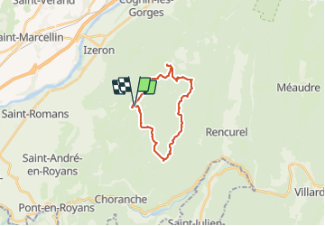

Length
19.6 km

Max alt
1426 m

Uphill gradient
789 m
Km-Effort
30 km

Min alt
996 m

Downhill gradient
787 m
Boucle
Yes
Creation date :
2021-08-22 07:08:48.0
Updated on :
2021-08-22 14:32:52.971
7h24
Difficulty : Very difficult

FREE GPS app for hiking
 SityTrail
IGN / Geographical institutes
SityTrail Plus
The world is yours!
About
Trail Walking of 19.6 km to be discovered at Auvergne-Rhône-Alpes, Isère, Presles. This trail is proposed by raygautier.
Positioning
Country:
France
Region :
Auvergne-Rhône-Alpes
Department/Province :
Isère
Municipality :
Presles
Location:
Unknown
Start:(Dec)
Start:(UTM)
688954 ; 4998703 (31T) N.
Comments