


Nointel randif

Glurps
User

Length
21 km

Max alt
200 m

Uphill gradient
385 m
Km-Effort
26 km

Min alt
21 m

Downhill gradient
385 m
Boucle
Yes
Creation date :
2021-08-22 08:21:20.0
Updated on :
2021-08-22 15:15:35.166
5h41
Difficulty : Very difficult

FREE GPS app for hiking
 SityTrail
IGN / Geographical institutes
SityTrail Plus
The world is yours!
About
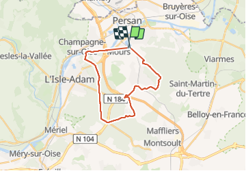
Trail Walking of 21 km to be discovered at Ile-de-France, Val-d'Oise, Nointel. This trail is proposed by Glurps.
Positioning
Country:
France
Region :
Ile-de-France
Department/Province :
Val-d'Oise
Municipality :
Nointel
Location:
Unknown
Start:(Dec)
Start:(UTM)
447326 ; 5442449 (31U) N.
Comments