


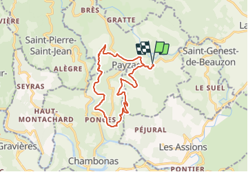
Payzac 15km

thonyc
User GUIDE

Length
14.6 km

Max alt
411 m

Uphill gradient
351 m
Km-Effort
19.3 km

Min alt
230 m

Downhill gradient
351 m
Boucle
Yes
Creation date :
2021-08-22 16:43:30.578
Updated on :
2021-08-22 22:02:17.575
4h22
Difficulty : Medium

FREE GPS app for hiking
 SityTrail
IGN / Geographical institutes
SityTrail Plus
The world is yours!
About
Trail Walking of 14.6 km to be discovered at Auvergne-Rhône-Alpes, Ardèche, Payzac. This trail is proposed by thonyc.
Positioning
Country:
France
Region :
Auvergne-Rhône-Alpes
Department/Province :
Ardèche
Municipality :
Payzac
Location:
Unknown
Start:(Dec)
Start:(UTM)
592183 ; 4922666 (31T) N.
Comments