


Chambon des neige la vallée de chaudefour 17 km

jeanic63
User
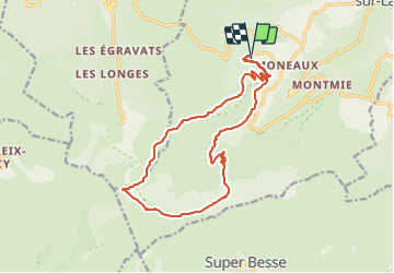

Length
16.7 km

Max alt
1831 m

Uphill gradient
877 m
Km-Effort
28 km

Min alt
1144 m

Downhill gradient
879 m
Boucle
Yes
Creation date :
2021-08-22 18:14:46.675
Updated on :
2021-08-23 16:09:29.333
6h03
Difficulty : Difficult

FREE GPS app for hiking
 SityTrail
IGN / Geographical institutes
SityTrail Plus
The world is yours!
About
Trail On foot of 16.7 km to be discovered at Auvergne-Rhône-Alpes, Puy-de-Dôme, Chambon-sur-Lac. This trail is proposed by jeanic63.
Description
départ parking des moneaux
Positioning
Country:
France
Region :
Auvergne-Rhône-Alpes
Department/Province :
Puy-de-Dôme
Municipality :
Chambon-sur-Lac
Location:
Unknown
Start:(Dec)
Start:(UTM)
488906 ; 5044766 (31T) N.
Comments