


Les coteaux de St Cloud et les rives de la Seine

c.chehere
User
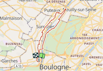

Length
14.9 km

Max alt
84 m

Uphill gradient
191 m
Km-Effort
17.5 km

Min alt
24 m

Downhill gradient
216 m
Boucle
Yes
Creation date :
2021-08-24 07:25:49.562
Updated on :
2021-08-24 15:33:24.682
4h43
Difficulty : Easy

FREE GPS app for hiking
 SityTrail
IGN / Geographical institutes
SityTrail Plus
The world is yours!
About
Trail Walking of 14.9 km to be discovered at Ile-de-France, Hauts-de-Seine, Saint-Cloud. This trail is proposed by c.chehere.
Description
Depuis la station "pont de St Cloud" du T2
Photos


Positioning
Country:
France
Region :
Ile-de-France
Department/Province :
Hauts-de-Seine
Municipality :
Saint-Cloud
Location:
Unknown
Start:(Dec)
Start:(UTM)
442769 ; 5410276 (31U) N.
Comments