


Annecy le Crêt du Maure la Boverie croix du chef lieu

f.frederich
User
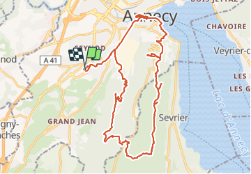

Length
26 km

Max alt
985 m

Uphill gradient
837 m
Km-Effort
37 km

Min alt
445 m

Downhill gradient
839 m
Boucle
Yes
Creation date :
2021-08-24 08:02:20.978
Updated on :
2021-08-24 19:52:24.932
11h49
Difficulty : Medium

FREE GPS app for hiking
 SityTrail
IGN / Geographical institutes
SityTrail Plus
The world is yours!
About
Trail Walking of 26 km to be discovered at Auvergne-Rhône-Alpes, Upper Savoy, Annecy. This trail is proposed by f.frederich.
Positioning
Country:
France
Region :
Auvergne-Rhône-Alpes
Department/Province :
Upper Savoy
Municipality :
Annecy
Location:
Seynod
Start:(Dec)
Start:(UTM)
274725 ; 5084887 (32T) N.
Comments