


Angon

f.frederich
User
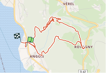

Length
6.6 km

Max alt
818 m

Uphill gradient
411 m
Km-Effort
12.1 km

Min alt
450 m

Downhill gradient
407 m
Boucle
Yes
Creation date :
2021-08-25 09:20:52.275
Updated on :
2021-08-25 13:30:23.91
4h09
Difficulty : Medium

FREE GPS app for hiking
 SityTrail
IGN / Geographical institutes
SityTrail Plus
The world is yours!
About
Trail Walking of 6.6 km to be discovered at Auvergne-Rhône-Alpes, Upper Savoy, Talloires-Montmin. This trail is proposed by f.frederich.
Positioning
Country:
France
Region :
Auvergne-Rhône-Alpes
Department/Province :
Upper Savoy
Municipality :
Talloires-Montmin
Location:
Talloires
Start:(Dec)
Start:(UTM)
284128 ; 5078743 (32T) N.
Comments