


ITI0081 2018

jeanic63
User
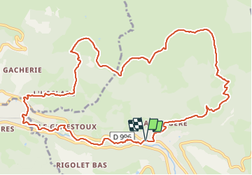

Length
14.5 km

Max alt
1479 m

Uphill gradient
631 m
Km-Effort
23 km

Min alt
888 m

Downhill gradient
632 m
Boucle
Yes
Creation date :
2021-08-25 16:06:45.258
Updated on :
2021-08-25 16:17:45.418
5h13
Difficulty : Medium

FREE GPS app for hiking
 SityTrail
IGN / Geographical institutes
SityTrail Plus
The world is yours!
About
Trail On foot of 14.5 km to be discovered at Auvergne-Rhône-Alpes, Puy-de-Dôme, Mont-Dore. This trail is proposed by jeanic63.
Description
départ le pont des marais (entre le mont dore et la bourboule) parking prés abri bus sur D996
Positioning
Country:
France
Region :
Auvergne-Rhône-Alpes
Department/Province :
Puy-de-Dôme
Municipality :
Mont-Dore
Location:
Unknown
Start:(Dec)
Start:(UTM)
484049 ; 5048216 (31T) N.
Comments