


plouezec

CABERMAT
User
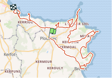

Length
31 km

Max alt
104 m

Uphill gradient
417 m
Km-Effort
37 km

Min alt
2 m

Downhill gradient
498 m
Boucle
No
Creation date :
2021-08-25 09:32:50.752
Updated on :
2021-08-25 16:46:03.012
5h19
Difficulty : Difficult

FREE GPS app for hiking
 SityTrail
IGN / Geographical institutes
SityTrail Plus
The world is yours!
About
Trail Mountain bike of 31 km to be discovered at Brittany, Côtes-d'Armor, Plouézec. This trail is proposed by CABERMAT.
Description
plouezec
Positioning
Country:
France
Region :
Brittany
Department/Province :
Côtes-d'Armor
Municipality :
Plouézec
Location:
Unknown
Start:(Dec)
Start:(UTM)
501091 ; 5399632 (30U) N.
Comments