


saint Jorioz vallée du Laudon

f.frederich
User
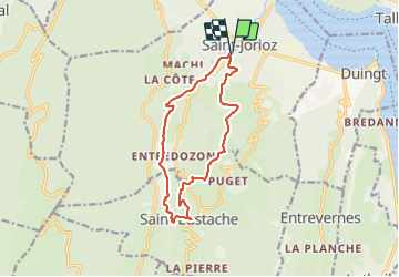

Length
13 km

Max alt
746 m

Uphill gradient
421 m
Km-Effort
18.7 km

Min alt
471 m

Downhill gradient
421 m
Boucle
Yes
Creation date :
2021-08-26 10:43:05.98
Updated on :
2021-08-26 15:22:50.012
4h39
Difficulty : Easy

FREE GPS app for hiking
 SityTrail
IGN / Geographical institutes
SityTrail Plus
The world is yours!
About
Trail Walking of 13 km to be discovered at Auvergne-Rhône-Alpes, Upper Savoy, Saint-Jorioz. This trail is proposed by f.frederich.
Positioning
Country:
France
Region :
Auvergne-Rhône-Alpes
Department/Province :
Upper Savoy
Municipality :
Saint-Jorioz
Location:
Unknown
Start:(Dec)
Start:(UTM)
279544 ; 5079254 (32T) N.
Comments