Trail Walking Goumois - Goumois 26 août 2021 (IBP 95) Arêtes de Sommmètres reco CAF - Photo

Goumois 26 août 2021 (IBP 95) Arêtes de Sommmètres reco CAF

© OpenStreetMap contributors
Length
Length
20 km
Max alt
Max alt
1092 m
Uphill gradient
Uphill gradient
992 m
Km-Effort
Km-Effort  
34 km
Min alt
Min alt
493 m
Downhill gradient
Downhill gradient
1002 m
Boucle
Boucle
Yes
Creation date :
2021-08-26 06:37:33.56
Updated on :
2021-08-28 07:42:09.902

(0 Reviews)

Walking
Walking
6h23
Difficulty : Difficult

Scan this QR Code to open this trail in the SityTrail application

FREE GPS app for hiking

Logo SityTrail SityTrail

IGN / Geographical institutes

Download SityTrail from the App Store Download SityTrail from Google Play

Logo SityTrail SityTrail World

The world is yours!

Download SityTrail from the App Store Download SityTrail from Google Play Download SityTrail on Huawei AppGallery

About

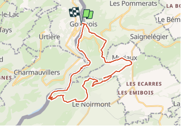
Trail Walking of 20 km to be discovered at Bourgogne-Franche-Comté, Doubs, Goumois. This trail is proposed by TRIMAILLE.

Description

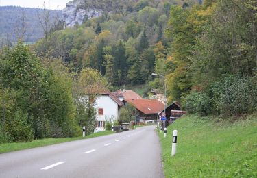
Départ de Goumois. La randonnée s'effectue principalement sur le versant Suisse.
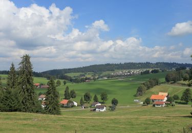
Aux arêtes de Sommètres allé/ retour à la croix et au refuge; jolie vue sur la vallée du Doubs jusqu'aux Vosges..
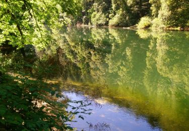
Les derniers Kms s'effectuent sur un bon chemin au bord du Doubs.

Elevation profile

Positioning

Country:
France
Region :
Bourgogne-Franche-Comté
Department/Province :
Doubs
Municipality :
Goumois
Location:
Unknown
Start:(UTM)
344890 ; 5236198 (32T) N.

Trails nearby

Trail On foot Le Noirmont - La Goule - fixme - Photo
On foot
PRO

On foot

Easy
Le Noirmont, Jura, District des Franches-Montagnes, Switzerland
3.4 km | 4.5 km-effort
1h 0min
No
Trail On foot Le Noirmont - La Goule - fixme - Photo
On foot
PRO

On foot

Easy
Le Noirmont, Jura, District des Franches-Montagnes, Switzerland
3.9 km | 8.2 km-effort
1h 51min
No
Trail On foot Muriaux - Muriaux - Goumois - Photo
On foot
PRO

On foot

Easy
Muriaux, Jura, District des Franches-Montagnes, Switzerland
4 km | 6.7 km-effort
1h 31min
No
Trail Walking Goumois - Les Sommêtres - Photo
Walking
tiene

Walking

Medium
Goumois, Bourgogne-Franche-Comté, Doubs, France
24 km | 37 km-effort
7h 54min
No
Trail Walking Charmauvillers - Goumois randonnée La Goule  - Photo
Walking
zazie

Walking

Medium
Charmauvillers, Bourgogne-Franche-Comté, Doubs, France
19.6 km | 35 km-effort
3h 5min
No
Trail On foot Saignelégier - Moulin Jeannottat-Les Pommerats - Photo
On foot
PRO

On foot

Easy
Saignelégier, Jura, District des Franches-Montagnes, Switzerland
4.3 km | 8.5 km-effort
1h 55min
No
Trail Walking Goumois - Goumois  - Photo
Walking
klopbill

Walking

Easy
Goumois, Bourgogne-Franche-Comté, Doubs, France
13.6 km | 19.4 km-effort
5h 42min
Yes
Trail Walking Fessevillers - Étape 4 : Fessevillers à Bief d'Etoz - Photo
Walking
annefrance70

Walking

Medium
Fessevillers, Bourgogne-Franche-Comté, Doubs, France
15 km | 21 km-effort
5h 14min
No
Trail Walking Goumois - La Chute du Bief de Vautenaivre et le Château Cugny. - Photo
Walking
tracegps

Walking

Medium
Goumois, Bourgogne-Franche-Comté, Doubs, France
15.2 km | 23 km-effort
5h 30min
Yes


Close
My subscriptions