


coincy oulchy villeneuve

bruno38
User
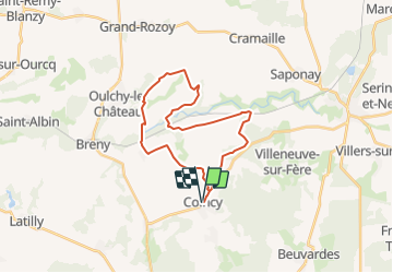

Length
24 km

Max alt
164 m

Uphill gradient
289 m
Km-Effort
28 km

Min alt
87 m

Downhill gradient
290 m
Boucle
Yes
Creation date :
2021-08-27 09:40:13.761
Updated on :
2021-08-30 09:14:33.125
6h21
Difficulty : Medium

FREE GPS app for hiking
 SityTrail
IGN / Geographical institutes
SityTrail Plus
The world is yours!
About
Trail On foot of 24 km to be discovered at Hauts-de-France, Aisne, Coincy. This trail is proposed by bruno38.
Positioning
Country:
France
Region :
Hauts-de-France
Department/Province :
Aisne
Municipality :
Coincy
Location:
Unknown
Start:(Dec)
Start:(UTM)
530784 ; 5445533 (31U) N.
Comments