


Montgeroult/Boissy-l'Aillerie_12kms_230DEN

philberard95
User
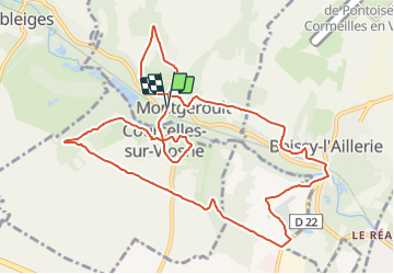

Length
12.1 km

Max alt
117 m

Uphill gradient
234 m
Km-Effort
15.2 km

Min alt
38 m

Downhill gradient
238 m
Boucle
Yes
Creation date :
2021-08-28 15:23:52.157
Updated on :
2021-08-28 15:25:14.58
3h27
Difficulty : Difficult

FREE GPS app for hiking
 SityTrail
IGN / Geographical institutes
SityTrail Plus
The world is yours!
About
Trail Walking of 12.1 km to be discovered at Ile-de-France, Val-d'Oise, Montgeroult. This trail is proposed by philberard95.
Positioning
Country:
France
Region :
Ile-de-France
Department/Province :
Val-d'Oise
Municipality :
Montgeroult
Location:
Unknown
Start:(Dec)
Start:(UTM)
427293 ; 5436931 (31U) N.
Comments