


chuzelles

fournieralain
User
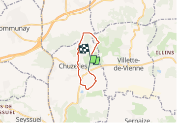

Length
7.5 km

Max alt
359 m

Uphill gradient
193 m
Km-Effort
9.8 km

Min alt
193 m

Downhill gradient
122 m
Boucle
No
Creation date :
2021-08-21 07:07:47.436
Updated on :
2021-08-29 07:51:03.754
2h07
Difficulty : Medium

FREE GPS app for hiking
 SityTrail
IGN / Geographical institutes
SityTrail Plus
The world is yours!
About
Trail Walking of 7.5 km to be discovered at Auvergne-Rhône-Alpes, Isère, Chuzelles. This trail is proposed by fournieralain.
Positioning
Country:
France
Region :
Auvergne-Rhône-Alpes
Department/Province :
Isère
Municipality :
Chuzelles
Location:
Unknown
Start:(Dec)
Start:(UTM)
647107 ; 5049486 (31T) N.
Comments