


2021-08-29 Bois noirs

Vacs
User
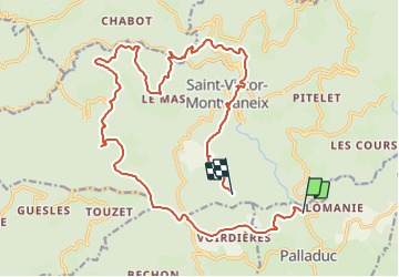

Length
22 km

Max alt
908 m

Uphill gradient
992 m
Km-Effort
35 km

Min alt
475 m

Downhill gradient
776 m
Boucle
No
Creation date :
2021-08-29 07:45:04.0
Updated on :
2021-08-29 11:04:39.67
1h45
Difficulty : Difficult

FREE GPS app for hiking
 SityTrail
IGN / Geographical institutes
SityTrail Plus
The world is yours!
About
Trail Mountain bike of 22 km to be discovered at Auvergne-Rhône-Alpes, Puy-de-Dôme, Palladuc. This trail is proposed by Vacs.
Positioning
Country:
France
Region :
Auvergne-Rhône-Alpes
Department/Province :
Puy-de-Dôme
Municipality :
Palladuc
Location:
Unknown
Start:(Dec)
Start:(UTM)
548649 ; 5084696 (31T) N.
Comments