


2021-08-29_18h09m05_Berges de la LEYSSE-G1(2)

papou73
User
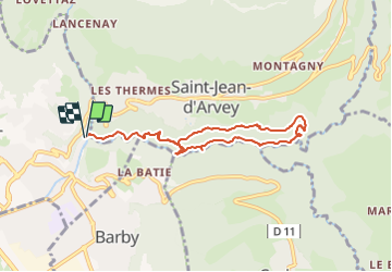

Length
7.8 km

Max alt
538 m

Uphill gradient
358 m
Km-Effort
12.6 km

Min alt
330 m

Downhill gradient
360 m
Boucle
Yes
Creation date :
2021-08-29 16:09:05.977
Updated on :
2021-08-29 16:12:18.492

FREE GPS app for hiking
 SityTrail
IGN / Geographical institutes
SityTrail Plus
The world is yours!
About
Trail of 7.8 km to be discovered at Auvergne-Rhône-Alpes, Savoy, Saint-Alban-Leysse. This trail is proposed by papou73.
Positioning
Country:
France
Region :
Auvergne-Rhône-Alpes
Department/Province :
Savoy
Municipality :
Saint-Alban-Leysse
Location:
Unknown
Start:(Dec)
Start:(UTM)
732204 ; 5051886 (31T) N.
Comments