


angervilliers

canal
User
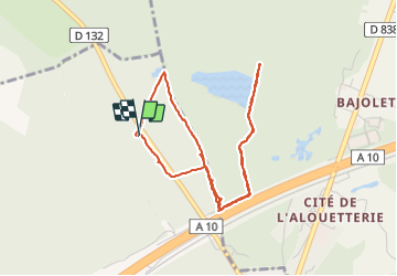

Length
4.4 km

Max alt
130 m

Uphill gradient
28 m
Km-Effort
4.8 km

Min alt
117 m

Downhill gradient
27 m
Boucle
Yes
Creation date :
2021-08-31 11:20:31.999
Updated on :
2021-08-31 13:14:54.393
1h54
Difficulty : Easy

FREE GPS app for hiking
 SityTrail
IGN / Geographical institutes
SityTrail Plus
The world is yours!
About
Trail Walking of 4.4 km to be discovered at Ile-de-France, Essonne, Angervilliers. This trail is proposed by canal.
Description
première sortie
Positioning
Country:
France
Region :
Ile-de-France
Department/Province :
Essonne
Municipality :
Angervilliers
Location:
Unknown
Start:(Dec)
Start:(UTM)
430182 ; 5383840 (31U) N.
Comments