


Hohwald

alinetpierre
User
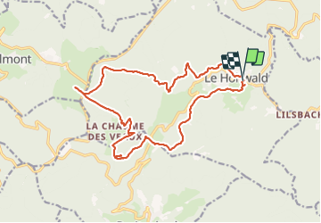

Length
18.4 km

Max alt
1073 m

Uphill gradient
660 m
Km-Effort
27 km

Min alt
567 m

Downhill gradient
666 m
Boucle
Yes
Creation date :
2021-09-01 07:42:56.0
Updated on :
2021-09-01 14:06:19.474
4h33
Difficulty : Medium

FREE GPS app for hiking
 SityTrail
IGN / Geographical institutes
SityTrail Plus
The world is yours!
About
Trail Walking of 18.4 km to be discovered at Grand Est, Bas-Rhin, Le Hohwald. This trail is proposed by alinetpierre.
Description
Cascade champ de feu
Positioning
Country:
France
Region :
Grand Est
Department/Province :
Bas-Rhin
Municipality :
Le Hohwald
Location:
Unknown
Start:(Dec)
Start:(UTM)
376353 ; 5362552 (32U) N.
Comments