


2021-09-01_18h20m37_ITINOR076V50W408

philberard95
User
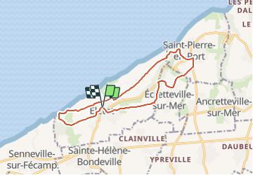

Length
12.8 km

Max alt
110 m

Uphill gradient
245 m
Km-Effort
16 km

Min alt
20 m

Downhill gradient
244 m
Boucle
Yes
Creation date :
2021-09-01 16:20:37.087
Updated on :
2021-09-01 16:35:56.37
3h38
Difficulty : Difficult

FREE GPS app for hiking
 SityTrail
IGN / Geographical institutes
SityTrail Plus
The world is yours!
About
Trail Walking of 12.8 km to be discovered at Normandy, Seine-Maritime, Életot. This trail is proposed by philberard95.
Positioning
Country:
France
Region :
Normandy
Department/Province :
Seine-Maritime
Municipality :
Életot
Location:
Unknown
Start:(Dec)
Start:(UTM)
316637 ; 5518271 (31U) N.
Comments