


2021-09-01_18h22m58_ITINOR076FS0001W

philberard95
User
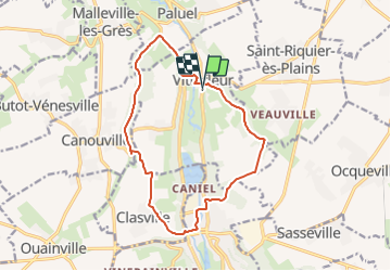

Length
13.6 km

Max alt
111 m

Uphill gradient
216 m
Km-Effort
16.5 km

Min alt
5 m

Downhill gradient
217 m
Boucle
Yes
Creation date :
2021-09-01 16:22:58.798
Updated on :
2021-09-01 16:33:11.288
3h45
Difficulty : Difficult

FREE GPS app for hiking
 SityTrail
IGN / Geographical institutes
SityTrail Plus
The world is yours!
About
Trail Walking of 13.6 km to be discovered at Normandy, Seine-Maritime, Vittefleur. This trail is proposed by philberard95.
Positioning
Country:
France
Region :
Normandy
Department/Province :
Seine-Maritime
Municipality :
Vittefleur
Location:
Unknown
Start:(Dec)
Start:(UTM)
330051 ; 5520934 (31U) N.
Comments