DIFFICILE Gesves

clemsdpp
User
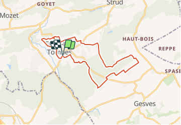

Length
14.3 km

Max alt
289 m

Uphill gradient
229 m
Km-Effort
17.4 km

Min alt
139 m

Downhill gradient
228 m
Boucle
Yes
Creation date :
2021-09-02 08:37:37.062
Updated on :
2021-10-09 20:19:34.626
3h46
Difficulty : Difficult

FREE GPS app for hiking
 SityTrail
IGN / Geographical institutes
SityTrail Plus
The world is yours!
About
Trail Walking of 14.3 km to be discovered at Wallonia, Namur, Gesves. This trail is proposed by clemsdpp.
Positioning
Country:
Belgium
Region :
Wallonia
Department/Province :
Namur
Municipality :
Gesves
Location:
Unknown
Start:(Dec)
Start:(UTM)
643614 ; 5587708 (31U) N.
Comments