


Lac Luitel - Mont Sec

maupassant38
User
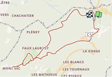

Length
12 km

Max alt
1408 m

Uphill gradient
521 m
Km-Effort
19 km

Min alt
1099 m

Downhill gradient
519 m
Boucle
Yes
Creation date :
2021-09-02 08:29:18.999
Updated on :
2021-09-02 12:25:22.16
2h46
Difficulty : Medium

FREE GPS app for hiking
 SityTrail
IGN / Geographical institutes
SityTrail Plus
The world is yours!
About
Trail Walking of 12 km to be discovered at Auvergne-Rhône-Alpes, Isère, Séchilienne. This trail is proposed by maupassant38.
Positioning
Country:
France
Region :
Auvergne-Rhône-Alpes
Department/Province :
Isère
Municipality :
Séchilienne
Location:
Unknown
Start:(Dec)
Start:(UTM)
724104 ; 4996546 (31T) N.
Comments