


reco Annevoie

William Vander Goten
User
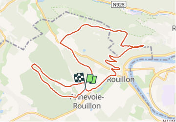

Length
11.3 km

Max alt
272 m

Uphill gradient
247 m
Km-Effort
14.6 km

Min alt
112 m

Downhill gradient
247 m
Boucle
Yes
Creation date :
2021-09-02 12:16:53.69
Updated on :
2021-09-02 14:56:06.507
2h38
Difficulty : Difficult

FREE GPS app for hiking
 SityTrail
IGN / Geographical institutes
SityTrail Plus
The world is yours!
About
Trail Walking of 11.3 km to be discovered at Wallonia, Namur, Anhée. This trail is proposed by William Vander Goten.
Description
Difficile
Positioning
Country:
Belgium
Region :
Wallonia
Department/Province :
Namur
Municipality :
Anhée
Location:
Unknown
Start:(Dec)
Start:(UTM)
630766 ; 5578516 (31U) N.
Comments