


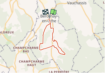
Bercenay en Othe

MoiClaude
User

Length
10.7 km

Max alt
272 m

Uphill gradient
203 m
Km-Effort
13.4 km

Min alt
172 m

Downhill gradient
202 m
Boucle
Yes
Creation date :
2021-09-02 11:52:31.506
Updated on :
2021-09-02 15:10:14.249
2h07
Difficulty : Difficult

FREE GPS app for hiking
 SityTrail
IGN / Geographical institutes
SityTrail Plus
The world is yours!
About
Trail Walking of 10.7 km to be discovered at Grand Est, Aube, Bercenay-en-Othe. This trail is proposed by MoiClaude.
Positioning
Country:
France
Region :
Grand Est
Department/Province :
Aube
Municipality :
Bercenay-en-Othe
Location:
Unknown
Start:(Dec)
Start:(UTM)
566260 ; 5339882 (31U) N.
Comments