


Mont St Odile mur païen sud et nord

alinetpierre
User
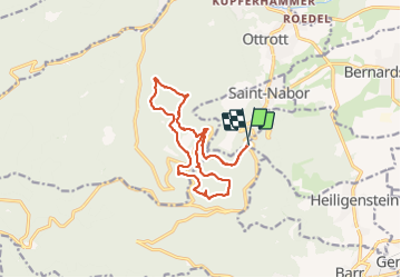

Length
16.2 km

Max alt
831 m

Uphill gradient
529 m
Km-Effort
23 km

Min alt
569 m

Downhill gradient
526 m
Boucle
Yes
Creation date :
2021-09-03 07:08:48.0
Updated on :
2021-09-03 13:33:41.684
4h31
Difficulty : Medium

FREE GPS app for hiking
 SityTrail
IGN / Geographical institutes
SityTrail Plus
The world is yours!
About
Trail Walking of 16.2 km to be discovered at Grand Est, Bas-Rhin, Obernai. This trail is proposed by alinetpierre.
Description
Départ Domaine St Jacques
Positioning
Country:
France
Region :
Grand Est
Department/Province :
Bas-Rhin
Municipality :
Obernai
Location:
Unknown
Start:(Dec)
Start:(UTM)
383000 ; 5365884 (32U) N.
Comments