


Les gorges de st pierrec

raygautier
User
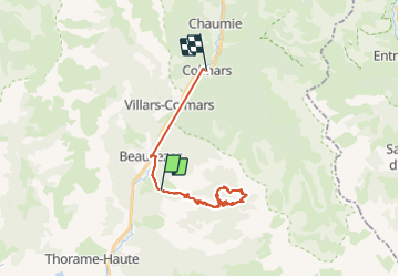

Length
26 km

Max alt
1939 m

Uphill gradient
1192 m
Km-Effort
42 km

Min alt
1149 m

Downhill gradient
1216 m
Boucle
No
Creation date :
2021-09-05 06:19:44.0
Updated on :
2021-09-05 14:39:40.55
8h03
Difficulty : Very difficult

FREE GPS app for hiking
 SityTrail
IGN / Geographical institutes
SityTrail Plus
The world is yours!
About
Trail Walking of 26 km to be discovered at Provence-Alpes-Côte d'Azur, Alpes-de-Haute-Provence, Beauvezer. This trail is proposed by raygautier.
Positioning
Country:
France
Region :
Provence-Alpes-Côte d'Azur
Department/Province :
Alpes-de-Haute-Provence
Municipality :
Beauvezer
Location:
Unknown
Start:(Dec)
Start:(UTM)
307889 ; 4888914 (32T) N.
Comments