


thormontbou

raab
User
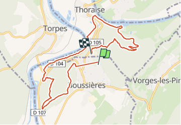

Length
10.4 km

Max alt
402 m

Uphill gradient
348 m
Km-Effort
15.1 km

Min alt
220 m

Downhill gradient
360 m
Boucle
No
Creation date :
2021-09-05 08:01:07.444
Updated on :
2021-09-05 19:47:33.579
3h26
Difficulty : Medium

FREE GPS app for hiking
 SityTrail
IGN / Geographical institutes
SityTrail Plus
The world is yours!
About
Trail Walking of 10.4 km to be discovered at Bourgogne-Franche-Comté, Doubs, Boussières. This trail is proposed by raab.
Positioning
Country:
France
Region :
Bourgogne-Franche-Comté
Department/Province :
Doubs
Municipality :
Boussières
Location:
Unknown
Start:(Dec)
Start:(UTM)
720308 ; 5227180 (31T) N.
Comments