


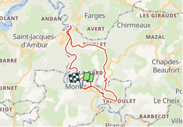
MONTFERMY cascade et abbaye

jpcccb
User

Length
15.3 km

Max alt
718 m

Uphill gradient
452 m
Km-Effort
21 km

Min alt
523 m

Downhill gradient
452 m
Boucle
Yes
Creation date :
2021-09-06 16:41:10.579
Updated on :
2025-02-03 10:23:20.228
4h51
Difficulty : Very difficult

FREE GPS app for hiking
 SityTrail
IGN / Geographical institutes
SityTrail Plus
The world is yours!
About
Trail Walking of 15.3 km to be discovered at Auvergne-Rhône-Alpes, Puy-de-Dôme, Montfermy. This trail is proposed by jpcccb.
Description
attention, ce tracé peut ne pas être praticable toute l'année, le long de la Sioule.
Positioning
Country:
France
Region :
Auvergne-Rhône-Alpes
Department/Province :
Puy-de-Dôme
Municipality :
Montfermy
Location:
Unknown
Start:(Dec)
Start:(UTM)
485154 ; 5080704 (31T) N.
Comments