


jdp

canal
User
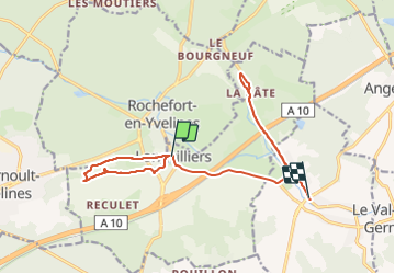

Length
15.1 km

Max alt
116 m

Uphill gradient
98 m
Km-Effort
16.4 km

Min alt
82 m

Downhill gradient
118 m
Boucle
No
Creation date :
2021-09-07 07:34:07.268
Updated on :
2021-09-07 12:08:43.732
2h35
Difficulty : Difficult

FREE GPS app for hiking
 SityTrail
IGN / Geographical institutes
SityTrail Plus
The world is yours!
About
Trail Walking of 15.1 km to be discovered at Ile-de-France, Yvelines, Longvilliers. This trail is proposed by canal.
Description
rando bota
Positioning
Country:
France
Region :
Ile-de-France
Department/Province :
Yvelines
Municipality :
Longvilliers
Location:
Unknown
Start:(Dec)
Start:(UTM)
425596 ; 5381091 (31U) N.
Comments